
GIS Mapping
The CFRPC produces maps and conducts geographic analysis to support a wide variety of projects. Most publications produced by the CFRPC include GIS Maps and GIS plays a crucial role in almost all CFRPC programs. The CFRPC maintains a comprehensive database of local and regional GIS data to support these efforts.
Planning Advisory Services
 The CFRPC provides Local Government Assistance through its Planning Advisory Program (PAS). Amoung the variety of services offered, the CFRPC provides professional GIS Mapping Services which assist local governments with an assortment of mapping needs including:
- Map Series for Comprehensive Plans – The CFRPC prepares and provides updates to the Map Series for the Comprehensive Plans, including but not limited to Future Land Use maps.
- Official Zoning Maps – The CFPRC prepares and provides updates to official zoning maps. These maps are made necessary by annexations, requests for re-zonings, and Comprehensive Plan Amendments.
- Special Project Maps – The CFPRC assists local governments with a variety of special projects needs. Special Projects maps might include Overlay District maps, Downtown Visioning maps, 3-Dimensional maps, and other specialty maps.
Affordable Parcel Inventory
The CFRPC has developed a methodology for and conducted an Affordable Parcel Inventory for residential parcels in seven local counties, including Okeechobee County (shown). The purpose was to estimate the affordability of residential parcels to households of median annual income. In this project, “affordability” is defined as a parcel’s total housing and transportation costs being less than 45% of median annual household income. Parcels that cost more than that are deemed “unaffordable”.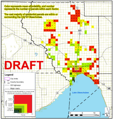
To estimate housing and transportation costs for each residential parcel, costs were estimated for both housing (such as potential mortgage payment or rent, utility costs, housing insurance, etc.) and transportation (based on distance from employment centers and household-support land uses such as shopping, groceries, schools, etc.). These costs combined represented the housing and transportation costs for each parcel. Data for the Affordable Parcel Inventory came from U.S. Census (2010), local property appraiser data, and original transportation cost estimates that were created by the University of Florida, specifically for this project.
In the map, color represents mean affordability, and number represents the number of parcels within each sector. Parcels are grouped by sector for clarity in viewing the information. Most residential parcels are in or surrounding the City of Okeechobee, where there is higher population density than in the remainder of the county.